Scenic Ontario road trip on Lake Superior's coastline
Follow the north shore of Lake Superior from Sault Ste. Marie to Thunder Bay and beyond on one of North America’s most spectacular summer drives.
This is the largest and most dramatic of the Great Lakes, where ancient cliffs plunge into sapphire water, waterfalls tumble through boreal forest and hidden beaches stretch for miles without a footprint in sight. Bring a sturdy pair of hiking boots and a sense of adventure for big water, massive views and endless skies.
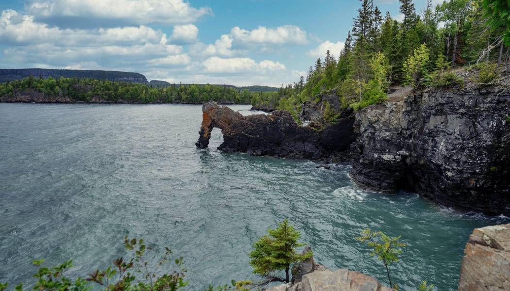
Sleeping Giant Provincial Park
Stop 1: Sault Ste. Marie, Ontario
Cross the Sault Ste. Marie International Bridge over the St. Marys River and arrive in Ontario’s Sault Ste. Marie, “The Soo” to locals, where Lake Huron meets Lake Superior.
Stroll the waterfront boardwalk for front-row views of freighters navigating the iconic Soo Locks. From here, connect to the Hub Trail, a scenic route linking downtown to Bellevue Park and top attractions like the Ermatinger-Clergue National Historic Site, the Art Gallery of Algoma and Canadian Bushplane Heritage Centre.
See and do nearby
Canadian Bushplane Heritage Centre
Peer into the area’s history of bush flying and forest protection, a heritage that remains very relevant today.
Location: 50 Pim Street, Sault Ste. Marie
Walk Among the Trees
Take an immersive journey into Anishinaabe cultural heritage on a guided walking tour.
Visit a First Nations garden and inquire about the culinary offerings included in the experience.
Location: 780 Landslide Road, Sault Ste. Marie
Hiawatha Highlands Conservation Area
Just minutes from downtown, explore multi-use mountain biking and hiking trails through old-growth pine forest and Canadian Shield outcrops. Hike to several viewing platforms at Crystal Falls in Kinsmen Park.
Robertson Cliffs Trails
One of Ontario’s top lookout trails, this scenic spot features three trail routes of varying lengths from 2.5–4.5 miles (4–7 kilometres) at intermediate difficulty. The trails are located approximately 30 minutes from downtown Sault Ste. Marie. Hike on your own or opt for a guided experience with Forest the Canoe.
Location: Robertson Lake Road, Goulais River
Food and drink
The Breakfast Pig
A staple for all-day breakfast food in Sault Ste. Marie uses ingredients sourced from nearby farms.
Location: 265 Bruce Street, Sault Ste. Marie
Uncle Gino’s Café and Restorante
Visit a popular, family-run pizzeria that’s been serving traditional Italian comfort food for decades.
Location: 56 Second Line West, Sault Ste. Marie
Peace Restaurant
Enjoy Asian fusion, tapas-style small plates and shareables and handcrafted cocktails in a lively atmosphere. Vegetarian, gluten-free and dairy-free options available.
Location: 250 Queen Street East, Sault Ste. Marie
Canal District
This historic industrial hub has been transformed into a vibrant cultural venue with several great dining options. The upscale Mill Steakhouse and Wine Bar is located in a fully renovated Machine Shop Building, part of the old paper mill. For a more casual ambiance, enjoy wood-fired pizza and one of several beers on tap at The Boiler Room.
Location: 83 Huron Street, Sault Ste. Marie
Outspoken Brewing
A hub for local culture, camaraderie and innovative craft beer housed in a historic building, serves in-house brews on tap, cocktails and a beer-paired menu.
Location: 350 Queen Street East, Sault Ste. Marie
Accommodations
Delta Hotel by Marriott
Sault Ste. Marie’s top waterfront hotel offers beautiful outdoor patio space and top-line amenities and services.
Location: 208 St Mary's River Drive, Sault Ste. Marie
Quattro Hotel
This all-suite property features an Italian, full spa and indoor pool.
Location: 229 Great Northern Road, Sault Ste. Marie
The Water Tower Inn
An on-site restaurant, indoor pool, hot tub, sauna and fitness facility make this hotel feel like a mini-resort.
Stop 2: Batchawana Bay
Approximate drive time and distance from Sault Ste. Marie: 1 hour, 44 miles (70 kilometres)
Travelling north on legendary Highway 17, part of the Trans-Canada Highway, the scenery shifts fast. Just beyond Goulais River, the road clings to the shoreline, and Lake Superior explodes into view.
There’s a reason it’s been called an inland ocean. Known as gichigamiing, “The Big Lake”, by the Anishinaabe, Lake Superior is as powerful as it is beautiful, famous for sudden storms, epic scale and the creative spirit it has stirred for generations.
See and do nearby
Chippewa Falls
Noted as the official halfway point of the Trans-Canada Highway, this roadside attraction features a parking area, restrooms and a picturesque hiking trail to the upper falls.
Location: Havilland, Algoma Country
Batchawana Bay Provincial Park
Soak in sunshine, waves and water views on this beautiful stretch of sandy beach.
Location: 10699 ON-17, Batchawana Bay
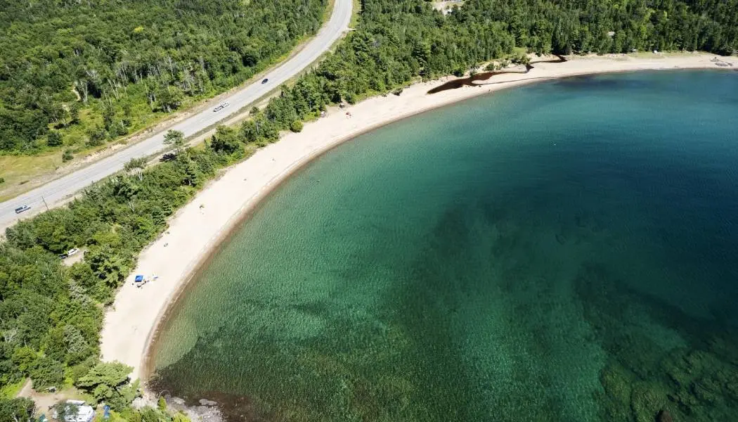
Pancake Bay Provincial Park
Another beautiful beach further along the shoreline, perfect for swimming and sunning. Hike to the Pancake Bay Lookout, known to locals as the Edmund Fitzgerald Lookout, a nod to the tragic sinking of the SS Edmund Fitzgerald Great Lakes freighter on November 10, 1975. This event inspired Gordon Lightfoot’s famous song, The Wreck of the Edmund Fitzgerald.
Location: 12729 Highway 17N, Batchawana Bay
Food and drink
The Voyageurs’ Deli and Bake Shop
The menu at The Voyageurs’ Lodge may appear modest, but this will be a meal you’ll remember, from the juicy burgers to the fresh whitefish tacos and the famous apple fritters. Stock up on snacks and fuel at the general store next door.
Location: ON-17, Batchawana Bay
Sunset Noodle House
Enjoy authentic homemade Vietnamese cuisine at Sunset Shores Resort.
Location: 10243 Trans-Canada Highway, Batchawana Bay
Agawa Fish and Chips
Famous for top-quality fresh and smoked trout and whitefish, Agawa Fishery operates a seasonal fish and chip stand across from Agawa Crafts & the Canadian Carver in Pancake Bay.
Location: 10212 ON-17, Batchawana Bay
Accommodations
McCauley’s Havilland Bay
Recently updated, this tranquil motel offers a full-service restaurant, comfortable rooms and Instagrammable views.
Location: 5235 ON-17, Algoma
The Voyageurs’ Lodge & Cookhouse
Seasonal lodging at The Voyageurs’ includes standard rooms and housekeeping suites equipped with a kitchen, living room, private bathroom and waterfront views of Batchawana Bay.
Location: ON-17, Batchawana Bay
Sunnd Eco Resort
Connect with nature at this peaceful, eco-friendly, Nordic-inspired spot featuring cozy and private glamping domes designed to bring the outside in. Book well in advance.
Location: 14904 ON-17, Batchawana Bay
Stop 3: Lake Superior Provincial Park
Approximate drive time and distance from Batchawana Bay: 1.5 hours, 77 miles (124 kilometres)
Highway 17 continues directly through Lake Superior Provincial Park. Note that there are no restaurants in the park, so stock up on food and snacks in advance.
See and do
Lake Superior Provincial Park Visitor Centre
Located at the south end of the park, this beautifully structured centre features an information desk, a gift shop, interesting exhibits and displays on the local area and its history, and access to the lake.
Location: Trans-Canada Highway, Agawa Bay
Scenic lookouts
Iconic lookout spots in the park include Alona Bay Scenic Lookout and Agawa Bay Scenic Lookout.
Beaches
Popular beach stops include Katherine Cove and Old Woman Bay.
Waterfalls
Beautiful waterfalls to explore in the park are Gargantua River Falls (a 3.7-mile/6-kilomentre return hike) and Agawa River Falls (along the 15-mile/24-kilometre Towab Trail).
Stop 4: Wawa
Approximate drive time and distance from Lake Superior Provincial Park: 1–2 hours, 62–80 miles (100–130 kilometres)
Wawa is where the wild begins. In the heart of Algoma Country, this laid-back northern town is surrounded by glassy lakes, thundering waterfalls, sandy beaches and endless forest.
It’s also the gateway to the Boreal Forest, the largest continuous forest on Earth, where the landscape stretches as far as your sense of adventure. Before you head out, pull over for a selfie with the town’s most famous resident: the towering Wawa Goose.
See and do nearby
Sandy Beach
Relax on warm, white sand dunes, venture into the water for a dip and learn about the Group of Seven connection from interpretive panels.
Location: Lake Superior, Wawa
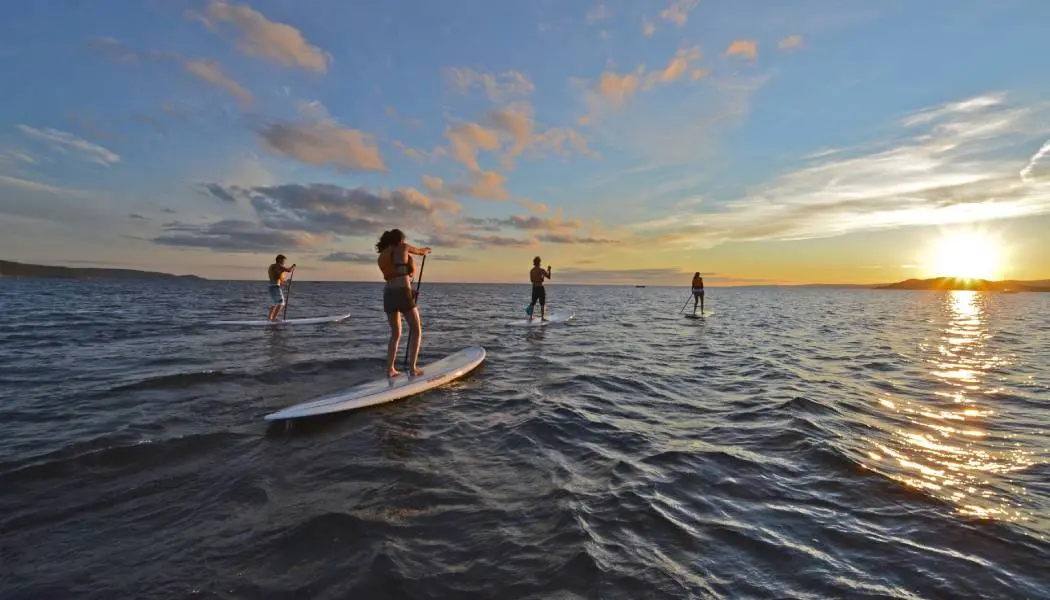
Get out on the ‘Big Water’ on a guided full or half-day SUPing or sea kayak excursion.
Location: 10 Government Dock Road, Wawa
Almost as tall as it is wide, this gorgeous cascade is a short drive south of Wawa off Highway 17. During peak flow, you can feel the mist from falls.
Location: Wawa
Food and drink
Young’s General Store
This popular pit stop is an eclectic landmark attraction famous for summer sausage, ice cream, maple syrup, homemade fudge, pickles and to-go food items.
Location: 105 Mission Road, Wawa
Wawa Goose Bar and Grill
The outdoor patio is a great spot to enjoy housemade burgers and a cold drink on a warm afternoon. It’s connected to the Wawa Motor Inn, making for a convenient rest stop.
Location: 118 Mission Road, ON-101, Wawa
Accommodations
Rock Island Lodge
A comfortable bed and breakfast-style accommodation facing Lake Superior at the mouth of the Michipicoten River, and operates in conjunction with Naturally Superior Adventures.
Location: 10 Government Dock Road, Wawa
Best Northern Motel and Restaurant
Conveniently located on Highway 17 just before the exit to Wawa, choose from motel rooms and two-bedroom cottages, and visit the onsite restaurant featuring an Indian and European menu.
Location: 150 ON-17, Wawa
Outdoorsman Motel
Clean, friendly and within walking distance to restaurants and shops, this friendly spot in the heart of town also offers fresh coffee and cookies to guests.
Location: 171 Mission Road, Wawa
Stop 5: Marathon and Pukaskwa National Park
Approximate drive time and distance from Wawa: 2–2.5 hours, 116 miles (187 kilometres)
North of Wawa, stop for another roadside attraction at the Winnie the Pooh Park in White River. Snap a picture of the statue of the iconic bear that inspired the beloved children’s stories.
The closest community to Pukaskwa National Park is Marathon, a small lakeside town brimming with walking and hiking trails.
See and do nearby
Pebble Beach
One of the most unique and colourful stretches of beach along the coast of Superior, Pebble Beach features a boardwalk and a lookout spot.
Location: 39 Howe Street, Marathon
Hawks Ridge Trail
Look for hawks and other wildlife on this moderate five-kilometre round-trip trail from Marathon.
Location: 127 Hemlo Drive, Marathon
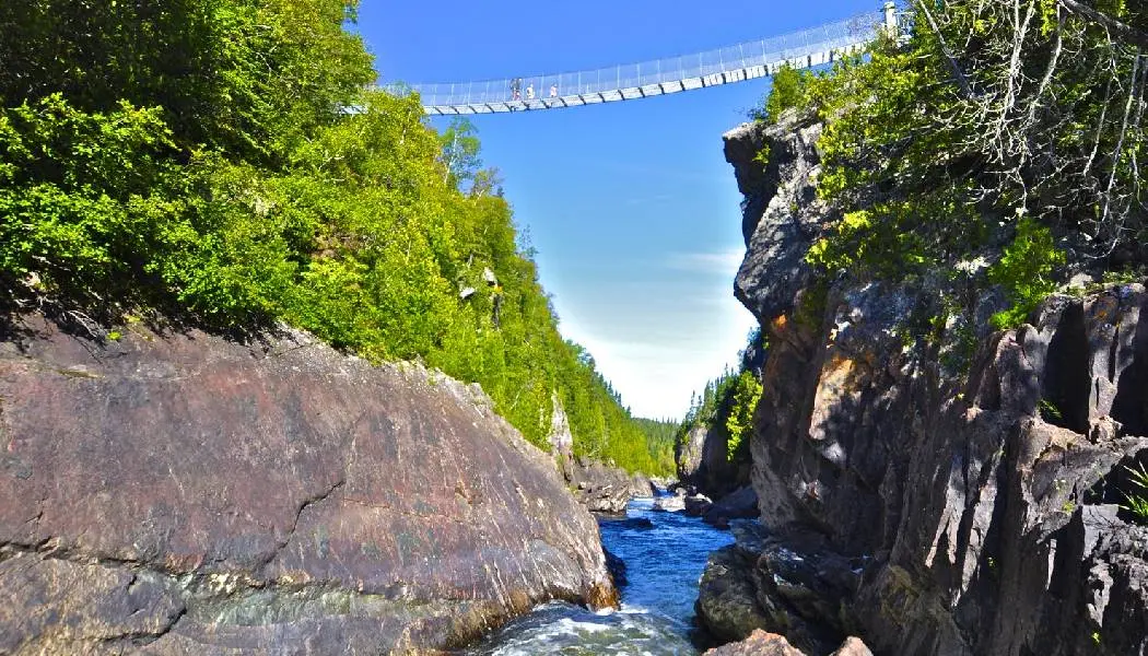
White River Suspension Bridge Trail
Start this day-hike adventure early. Part of the famous Coastal Hiking Trail, this 11-mile (18-kilometre) route includes crossing a suspension bridge high above a roaring waterfall.
There are also several other trails available in the park, including accessible facilities and a wheelchair-friendly boardwalk beach trail to Hattie Cove that leads to Horseshoe Bay.
Location: ON-627, Heron Bay, Pukaskwa National Park
Food and drink
The Oar House Restaurant
A family-run diner-style restaurant serving classic comfort food.
Location: 88 Evergreen Street, Marathon
Accommodations
Dreamscapes Inn
Spacious suites include a private ensuite and an in-room mini fridge at this peaceful, adult-focused inn.
Location: 7 Cherry Lane, Marathon
oTENTik campsites in Pukaskwa
A fun alternative to camping in Pukaskwa is the oTENTik tent units, which are a cross between a tent and a rustic cabin. You’ll need to make reservations well in advance.
Stop 6: Terrace Bay and Neys Provincial Park
Approximate drive time and distance from Marathon: 45 minutes–1 hour, 116 miles (44–50 kilometres)
Between Marathon and Terrace Bay, stop at Neys Provincial Park to visit Neys Scenic Point and Pic Island Scenic Lookout, made famous by the renowned Group of Seven artists.
The area is surrounded by the rugged Northern Ontario wilderness, including Slate Island Provincial Park (an island known for woodland caribou and the remains of First Nations settlements) and Neys Provincial Park.
In Terrace Bay, visit the downtown lighthouse and climb the staircase for breathtaking views of Lake Superior and the town itself. Stock up on groceries, snacks and more at Simcoe Plaza.
See and do nearby
Terrace Bay Beach
A lovely beach area for sunning and picnicking, with pavilion and washroom facilities.
Location: Beach Road, Terrace Bay
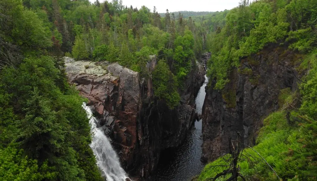
Aguasabon Falls and Gorge
Easily accessible boardwalks and platforms provide excellent viewpoints of these mighty waterfalls and the gorge.
Location: 2 Aguasabon Gorge Road, Terrace Bay
Casque Isles Trail
Yet another must-hike trail in Northern Ontario. Part of the Voyageur Trail Association, this 33-mile (53-kilometre) route links several communities along Lake Superior’s shoreline with moderate day-hike sections for the casual hiker, such as the Lyda Bay Segment from Terrace Bay.
Location: Beach Road, Terrace Bay
Food and drink
Drifters Restaurant
Next to Drifters Motel, this casual restaurant and bar offers generous portions of pasta, burgers, pizza, salads and more.
Location: 3 Simcoe Plaza, Terrace Bay
Slate Island Brewing Company
Enjoy a pint of finely brewed beer and taproom snacks.
Location: 9 Simcoe Plaza, Terrace Bay
Accommodations
Drifters
Centrally located motel featuring comfortable, fully equipped and uniquely decorated suites.
Location: 3 Simcoe Plaza, Terrace Bay
Cypress Sleeper Barrels
Feel the calming and healing power of nature at this unique waterfront sanctuary. Cozy, handcrafted cedar barrels with bubble windows invite you to rest, relax and soak in lake views and starry skies.
Location: 1 Nipigon Bay Road, Thunder Bay
Stop 7: Nipigon and Sleeping Giant Provincial Park
Approximate drive time and distance from Terrace Bay: 1 hour, 15 minutes, 65 miles (105 kilometres)
As you approach Nipigon, a scenic viewing spot marks the northernmost point of Lake Superior and the Great Lakes overlooking Kama Bay.
Nipigon serves as a gateway community for exploring the dramatic Palisades formations of the Canadian Shield and epic trails in nearby parks. It’s also a world-class freshwater fishing destination; the Nipigon River is famously where the world record for largest brook trout was caught. In town, visit the Bridgeview Tower for a scenic view of Nipigon.
See and do nearby
Kama Cliffs Trail
Located within the Lake Superior National Marine Conservation Area, this scenic hike leads to amazing views of Lake Superior, the Kama Cliffs, Kama Point and various islands.
Location: Trans-Canada Highway, Dublin
Such a Nice Day Adventures
Explore the Rossport Islands in the Superior National Marine Conservation Area on a guided full-day wilderness sea kayaking tour.
Location: 121 Lloyd Lane, Rossport
Sleeping Giant Provincial Park
With over 62 miles (100 kilometres) of hiking trails, stunning views and excellent wildlife opportunities, you could spend a full week in this park. Notable hikes include the Sea Lion and the Top of the Giant Trail.
Location: R R 1, Pass Lake
Nipigon River Recreation Trail
This rugged, wilderness trail runs between Nipigon and Red Rock along the shoreline of the Nipigon River with clifftop lookouts and incredible bird watching opportunities.
Location: Red Rock
Ruby Lake Trail Lookout
At just over 1.4 miles (two kilometres) long, this relatively short hike leads to an incredible view of Lake Superior.
Location: Unnamed Road, Thunder Bay
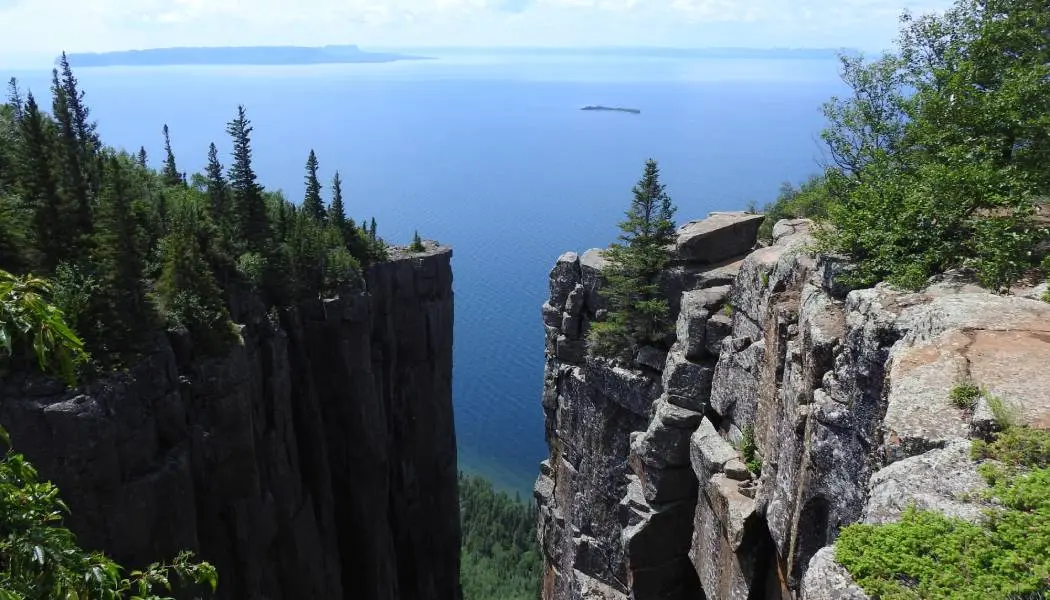
Ouimet Canyon Provincial Park
It’s worth the stop at this day-use-only park for panoramic views of a 164-yard (150-metre) wide gorge and sheer cliffs. A trail and boardwalk connect to two lookout platforms.
Location: Pass Lake, Ontario
Food and drink
Ducky’s Diner
Enjoy classic comfort food done right at this favourite local diner, including the popular fried chicken poutine.
Location: 522 Trans-Canada Highway #11-17, Nipigon
Canyon Country Co-op
A one-stop shopping spot for just about anything you need on-the-go, from take-out food and grocery essentials to camping supplies and souvenirs.
Location: 920 Highway 11-17, Dorion
Accommodations
Town & Country Motel
A recently renovated upscale family-owned motel, offering comfort and convenience in the heart of Nipigon.
Location: 442 Highway 11-17, Nipigon
The Lodge at Red Rock
This rustic, lakeside log cabin retreat beckons with cozy rooms, a crackling fire in the common lounge area and magnificent lake and forest views.
Location: Red Rock
Stop 8: Thunder Bay
Approximate drive time and distance from Nipigon: 1 hour, 25 minutes, 72 miles (116 kilometres)
On Lake Superior’s north shore, Thunder Bay is Northwest Ontario’s largest city, and your gateway to big views and big stories.
Start at the Terry Fox National Historic Monument, where a towering tribute honours the Canadian hero who began his cross-country run for cancer research here in 1980. The lookout delivers a sweeping view of Lake Superior and the unmistakable silhouette of the Sleeping Giant rising from the water.
For another unforgettable panorama, head up to Mount McKay Lookout. From the summit, the city, shoreline and Sleeping Giant stretch out in one epic, wind-in-your-hair vista.
See and do nearby
Fort William Historical Park
At one of North America’s largest living history sites, costumed actors bring this reconstructed circa-19th-century fur-trading post to life. It’s also home to one of Ontario’s largest telescopes, which is accessible to the public at the David Thompson Astronomical Observatory.
Location: 1350 King Road, Thunder Bay
Sail Superior
Join Sail Superior for a sailboat, catamaran or zodiac adventure on Lake Superior.
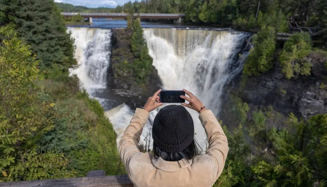
Kakabeka Falls Provincial Park
Don’t miss the “Niagara of the North.” This 131 feet-tall (40-metres) plunge waterfall along the Kaministiquia River features several viewing decks connected by boardwalk and trail.
Location: 4853 ON-11 #17, Kakabeka Falls
Food and drink
Goods & Co. Market
This vibrant urban market is home to several eateries, including the recently resurfaced Hoito Restaurant, a beloved staple of Finnish culture in Thunder. Sample authentic Finnish pancakes with real maple syrup. Follow the Hoito on Facebook for the full menu.
Location: 251 Red River Road, Thunder Bay
Subdivision
Pair delicious Detroit-style pizza with a local brew at the casual eatery located next to Lakehead Beer Co. in downtown Port Arthur.
Location: 206 Park Avenue, Thunder Bay
Bight Restaurant & Bar
Great waterfront views accompany a delicious brunch, lunch or dinner menu.
Location: 2201 Sleeping Giant Parkway, Unit 100, Thunder Bay
Caribou Restaurant + Wine Bar
North American bistro-style eatery serving an eclectic menu inspired by dishes from Italy and Korea.
Location: 727 Hewitson Street, Thunder Bay
Accommodations
The Courthouse Hotel
An elegant boutique hotel in a historic setting. In its past, this building was a Superior Court of Justice. Today, it embraces classical revival-style architecture blended with modern design.
Location: 277 Camelot Street, Thunder Bay
Delta Hotels Thunder Bay
Upscale and modern hotel with a waterfront park setting and views of the Sleeping Giant and Lake Superior.
Location: 2240 Sleeping Giant Parkway, Thunder Bay
Stop 9: Pigeon River
Approximate drive time and distance from Thunder Bay: 45 minutes, 38 miles (62 kilometres)
The Pigeon River flows along a section of the Canada–United States border between Minnesota and Ontario and drains into Lake Superior.
See and do nearby
James Duncan Nature Trail
Explore almost 10 kilometres of hiking trails in the Big Trout Bay Nature Reserve with spectacular lake views.
Location: Cottage Drive West, Neebing
High Falls of the Pigeon River
Follow a 1.5-mile (2.5-kilometre) loop trail to the viewing platform at these scenic falls. You can also see the viewing platform across the Pigeon River on the U.S. side.
Location: High Falls Trail, South Gillies
Crossing the border
Required documents
U.S. visitors to Canada must present a valid passport or NEXUS card.
Find out what else you’ll need to know to cross the border into Canada.
Border crossing locations
There are several road border crossings from the United States into Ontario. The closest border crossing locations between the U.S. and Canada for this itinerary include:
- Sault Ste. Marie International Bridge, Michigan to Sault Ste. Marie, Ontario
- Grand Portage, Pigeon River International Bridge, Minnesota, Pigeon River
Before travelling, check border wait times.
Know before you go
Find more valuable local insights and trip planning information for Sault Ste. Marie, Algoma Country, Thunder Bay and Sunset Country.
Contact an Ontario travel planner for help in creating a customized itinerary that meets your needs.
Getting around and accessibility
You’ll need a private vehicle to complete this Ontario road trip in its entirety. Make sure you’re familiar with the basic rules of the road and search for EV charging stations using Natural Resources Canada.
Download the Access Now app to search for accessible businesses, trails and outdoor experiences in Ontario.
Visiting Ontario Park
This itinerary includes suggested accommodations, such as hotels, motels and inns; however, if you are planning to camp, most Ontario Provincial Parks offer a variety of campsite options.
Make camping reservations and/or daily vehicle permits in advance. An annual park pass is a great way to save money and time for frequent park visitors.
Weather
Summers in Ontario are warm and pleasant, with the possibility of hot and humid conditions. Spring and fall conditions are more variable, with the chance of frost and more precipitation before mid-May and after mid-September.
Learn more about the weather in Ontario and get suggestions on what to pack and how to prepare for your trip.
Currency, measurements and holidays
Find useful things to know about Ontario, including Canadian currency, measurements and public holidays acknowledged in the province.
Safety information
Nature takes centre stage in Northern Ontario, so be prepared and aware of wildlife, both big and small.
Pack bug spray to avoid the mosquitoes in the warmer months. While driving, be vigilant for animals on the road, particularly at dusk and dawn, including bears, moose and deer.
Emergencies aren’t always the first thing we consider when planning a vacation, but knowing who to contact in an emergency is important.
Last updated: April 17, 2026