Ultimate Ontario fall colour lookouts
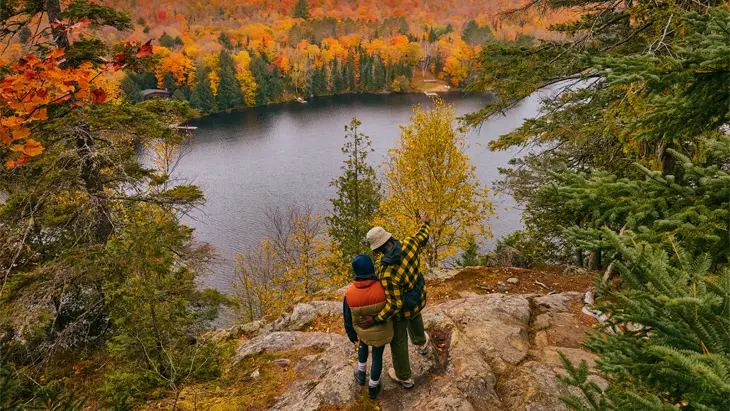
Oxtongue Lake
From climbing old fire towers to hiking rocky mountain cliffs, you’ll be rewarded with breathtaking views lit up by a colourful medley of greens, ambers, golds and reds at these lookout spots.
For your safety and to preserve sensitive landscapes, follow signage and instructions on all trails, boardwalks and lookouts and check weather conditions before departure.
Hike to one of these lookouts on your next fall season getaway in Ontario.
Haliburton Highlands to the Ottawa Valley
Eagle’s Nest Lookout, Calabogie
The hike to this lookout begins at Calabogie Peaks Resort with an easy 1.5 kilometres (just under a mile) walk up a slow incline to the 120 metre (394 foot) high cliff-top for a spectacular bird’s eye view of the wilderness below.
Or opt for the longer nine-kilometre (5.6-mile) Manitou Mountain trail that passes three other mountain vistas before leading up to the money shot at Eagle’s Nest Lookout.
This trail is not to be confused with Eagle’s Nest Bancroft, which provides a stunning view of the York River Valley in Hastings Highlands.
Make it an overnight getaway. Choose from boutique, redesigned motel rooms at Somewhere Inn Calabogie or mountainside condos at Calabogie Peaks Resort.
Location: Calabogie Road (508), about 100 kilometres (one hour drive) west of Ottawa. Drive to the trailhead on Highway 508 West, 2.2 kilometres past Calabogie Peaks Resort; parking is available on the right side of the road.
Dorset Scenic Tower, Algonquin Highlands
Built in 1922 as a lookout for potential forest fires, this historic structure is strictly a tourist attraction today with an awesome 360-degree view 142 metres (465 feet) above Lake of Bays in the gorgeous Haliburton Highlands area.
The Dorset Lookout Tower Trail begins behind the Dorset Heritage Museum on Main Street and continues for over two kilometres uphill through mixed forest to the base of the 30 metre (100 foot) tall tower. Catch your breath and climb up. The scene from the top is well worth the effort.
The operating season runs from May through October. During the fall colour season, this attraction is very popular. Tickets must be purchased in advance, and parking fees apply. Timed entry tickets become available in early September.
Nearby in Huntsville, check out Lion's Lookout. A 1.5-kilometre-long road accessed via Forbes Hill Drive and Camp Kitchen Road climbs up over the Muskoka River and Fairy Lake, with an overlook offering spectacular views of the city beneath and the surrounding hills. There is limited parking at the top; more parking is available at the Recreation Centre below.
Haliburton Highlands and Muskoka offer a variety of accommodation options, from upscale lakeside Deerhurst Resort to Firehouse Lodge and cozy cabins at Haliburton Forest.
Location: 1191 Dorset Scenic Tower Road (located off Highway 35, just north of the village of Dorset), 40 kilometres (30 minutes drive) east of Huntsville and 60 kilometres (about a 50-minute drive) northwest of Haliburton.
Beetle Lake Trail, Dwight
Hike through a hardwood forest past rocky ridges for magnificent cliff views of Oxtongue Lake, just east of Dwight.
What previously was a five-kilometre trail circling the northern arm of Oxtongue Lake is temporarily two trails along each side of the lake due to recent damage to the footbridge over Oxbow Creek. However, you can still enjoy the hike on both sides, with the massive 30 metre high cliff lookout on the east side trail.
Nearby, the Limberlost Forest and Wildlife Reserve offers lakefront lodging and rustic cabins, as well as campsites.
Location: Trailhead is off Elliott Road, north of Highway 60
Algonquin Park, Muskoka and Parry Sound
Tower Hill Lookout & Heritage Garden, Parry Sound
For a stunning panoramic view of Georgian Bay, climb the 130 steps of the 30-metre-high observation tower at the Tower Hill Lookout & Heritage Garden in Parry Sound.
Initially built in the 1920s as a fire lookout tower and a public observation point, the tower was designed both to entertain and to educate visitors about forest safety—a major concern for the local logging industry after the Great Fire of 1916.
After taking in the views, come back to earth and stroll through the historic gardens below, complete with a goldfish pond and a pedestal sundial. Visit the Museum on Tower Hill to learn more about local history—everything from shipwrecks to the local logging trade and what life was like in the late 19th and early 20th centuries.
Parry Sound offers overnight visitors a wide range of accommodations. For a comfy stay in the heart of the city, try the Jolly Roger Inn and Resort.
Location: 17 George Street, Parry Sound, just east of downtown, access the Tower Hill Lookout on foot (about a 20-minute walk) or by car (five-minute drive) via Seguin Street and Great North Road.
Northeastern Ontario
East Lookout, Manitoulin Island
There are several trails along the Manitoulin Extension of the Niagara Escarpment, including the Cup and Saucer Trail that leads up a 350 metre (1148 foot) climb to the highest point on Manitoulin Island just past the East Lookout.
The trail begins at the parking lot on Bidwell Road and Highway 540 and involves a few ladder and rope climbs on the way to the top of the imposing 70 metre (230 foot) tall cliffs.
Complete your getaway with a stay at The Manitoulin Hotel & Conference Centre. The hotel design was inspired by the beauty of the region and the First Nations culture on Manitoulin.
Location: Cold Springs, at the intersection of Highways 540 and Bidwell Road, 24 kilometres south of Little Current, north of M’Chigeeng on Manitoulin Island.
Temagami Tower, Temagami
For unmissable views in Northeastern Ontario, the Temagami Tower and viewing platform is one of the best spots to take in the surrounding landscape of vast forests, dotted with crystal-blue lakes.
The tower sits atop Caribou Mountain in the middle of the 800-hectare White Bear Forest, home to many of the province’s oldest pine trees, some more than 500 years old!
Originally constructed of wood in 1910, the modern steel tower is the area’s most famous landmark. On a clear day, you might even spot the tower’s twin on Maple Mountain, one of the highest points in Ontario.
Visitors looking for lodging nearby can find both dining and accommodation at Temagami Shores Inn and Restaurant. Fishing, ATV and snowmobile enthusiasts will discover lots of fun outdoor activities at Lake Herridge Lodge and Resort.
Location: Find the tower at 112 Jack Guppy Way, Temagami, just a five-minute drive (or 30-minute walk) from the town of Temagami. From Highway 11, head east on O’Connor Drive. Then turn right onto Jack Guppy Way and follow the road as it winds around toward the tower parking lot at the end of the road. The tower is a short walk from the parking lot.
Sault Ste. Marie and Algoma
Robertson Cliffs, Sault Ste. Marie
Ila’s Loop hike to Robertson Cliffs is one of the many stunning hikes in the Algoma area. It’s located about half an hour north of Sault Ste. Marie.
Part of the Voyageur Trail Association, the loop is approximately five kilometres, starting from the trailhead on Robertson Lake Road, off of Old Highway 17, and is marked with white signage. Follow the blue trail to reach Robertson waterfalls, before returning to the main trail and climbing up to the top of a 150-metre tall cliff formation. The views of the boreal forest below and Lake Superior beyond are incredible. The yellow-marked trail is your best option for your descent as it has a less steep grade.
If you prefer a guided experience, join Forest the Canoe on a three-hour, interpretive hike to Robertson Cliffs.
The Water Tower Inn features luxury rooms and suites, hot tubs, sauna, swimming pool, fitness centre and grill pub—the perfect end to a day of hiking.
Location: Outside of Goulais River, 35 kilometres (30 minutes drive) north of Sault Ste. Marie on Trans-Canada Highway 17. Parking is available on the right side of Robertson Lake Road.
Fire Tower Lookout, Elliot Lake
Elliot Lake Fire Tower offers a spectacular view of Algoma’s autumn foliage from one of the region’s highest points. Cast your eyes across the orange, red and pink treetops, looking south toward Westner Lake. On a clear day, you might even glimpse Manitoulin Island.
Learn more about the region’s history—and grab a snack and a few souvenirs—in the nearby Fire Ranger’s Heritage Centre, a restored cabin that was once home to the tower watchman and his family.
Nearby, explore beautiful lakes, waterfalls and clifftops along the Deer Trail Drive, which runs from Elliot Lake through Mississagi Provincial Park to Iron Bridge and Blind River.
For a comfortable stay, visit the Hampton Inn by Hilton Elliot Lake on Highway 108.
Location: Fire Tower Road, Elliot Lake is an eight-minute drive from Elliot Lake. Travelling north on Highway 108, turn right (east) onto Milliken Mine Road and follow this for about three kilometres until you see Fire Tower Road on your right. The Tower is at the end of the road.
Northwest Ontario
Ouimet Canyon, near Thunder Bay
About an hour’s drive northeast of Thunder Bay, off the Trans Canada Highway, lies Ouimet Canyon, one of Ontario’s most dramatic vistas.
Located within Ouimet Canyon Provincial Park, the vast 150 metre (492 foot) wide gorge is flanked by 100 metre (328 foot) deep sheer cliff faces and extends over 2,000 metres (6562 feet) long. Follow the groomed trail and boardwalk, connecting two observation platforms for the ultimate viewing spot.
Cross Canada’s longest suspension footbridge at Eagle Canyon Adventures nearby and head to Thunder Bay for accommodations. Both the Prince Arthur Waterfront Hotel & Suites and The Courthouse Hotel are great downtown options with views of Lake Superior.
Location: Greenwich Lake Road, Pass Lake, 85 kilometres east of Thunder Bay, exit onto Ouimet Canyon Road off Highway 17 (Trans Canada Highway).
Southeastern Ontario
Spy Rock Lookout, Westport
A half-hour drive south of Perth in Southeastern Ontario, Foley Mountain Conservation Area in the Rideau Valley is home to a fantastic viewpoint atop a protruding granite ridge. The showstopping view includes Upper Rideau Lake and the village of Westport.
There are five marked trails, including the wide, crushed stone, low-grade Mobility Trail that allows for wheelchair access to the lookout point. The conservation area lies within the Frontenac Arch, one of four UNESCO-designated World Biosphere Reserves in Ontario and part of Ontario’s Amazing Places program.
About an hour’s drive south is another incredible lookout within the biosphere. A remarkable view of the 1000 Islands and St. Lawrence River awaits from the 122 metre (400 foot) high observation deck at the top of the 1000 Island Tower. This attraction includes an elevator.
Soak up small-town hospitality at The Cove Country Inn overlooking the lake in Westport.
Location: 105 Foley Mountain Lane, Westport, 55 kilometres (under an hour drive) north of Kingston.
Rock Dunder Nature Reserve, near Gananoque
Another of the many gems found with the Thousand Islands Frontenac Arch Biosphere Reserve, Rock Dunder looks out over Morton Bay with great views of the lakes and forest below.
Open mid-May to mid-November, the trail is just under four kilometres and takes about an hour to hike. You’ll need to purchase passes for this popular spot.
Find various accommodation options in and around Gananoque to continue exploring.
Location: 72 Stanley Lash Line, Lyndhurst
Bruce, Grey and Simcoe
Skinners Bluff Scenic Lookout, Wiarton
Just northeast of Wiarton in Grey County, on an extension of the Bruce Trail, is a massive rock jutting out of the landscape like a natural viewing platform.
The full Skinner’s Bluff Trail system is 19 kilometres (12 miles), but you can beeline from the parking lot to the lookout spot in just 15 minutes. Take care over the rocky terrain and steep drops along the way.
The best views are from the east and north sides of the escarpment overlooking the forest below and the shining waters and islands dotting Colpoy’s Bay, a scenic inlet of Georgian Bay.
Waterview Resort is the closest waterfront accommodation outside of Wiarton, home to Canada’s most famous groundhog. Cozy cabins, fun events and great stargazing opportunities make Red Bay Lodge a wonderful stay nearby. Or book one of the getaway packages offered at Scandinave Spa Blue Mountain.
Location: 502729 Grey Road 1, east of Wiarton, 75 kilometres (under an hour drive) south of Tobermory and 95 kilometres (just over an hour drive) northwest of Blue Mountain.
Hamilton, Halton and Brant
Rattlesnake Point, Milton
Rattlesnake Point Conservation Area in Milton is beautiful in every season, but in fall, it is nothing short of breathtaking. This spot is a mecca for rock climbers with sheer cliffs, cave systems and rock crevices.
The park features several trails of varying levels of ease, including the Buffalo Crag Trail. It begins at the parking lot and follows along the edge of the Niagara Escarpment cliffs to stellar lookout points of the Nassagaweya Canyon below and countryside beyond. Reservations may be required to visit select Conservation Areas during busy periods; check in advance and make your booking online.
The lesser-known Mount Nemo Conservation Area also features a ribbon of exposed rock face with equally impressive views from the top. You can see the Toronto skyline on a clear day. Keep an eye out for mighty turkey vultures soaring by.
Treat yourself to the height of luxury, elegance and hospitality at Langdon Hall Country Hotel & Spa in nearby Cambridge.
Location: 7200 Appleby Line, Milton, approximately 60 kilometres (45 minutes drive) west of downtown Toronto.
York, Durham and Headwaters
Cheltenham Badlands, Caledon
West of Caledon on Olde Base Line Road, and only an hour’s drive from Toronto, lies an amazing geological site so alien-looking it could be the set for a Star Trek episode. The undulating rust and red-coloured rocks marked by ribbons of white veins are a result of exposed and eroded shale and the striking colour is due to iron oxide deposits.
This sensitive landscape is protected and is only accessible to the public from a boardwalk and designated trails. Though not technically a hike up, the scene from the viewing platform in the fall is a spectacle you don’t want to miss – waves of rolling red rock framed by blazing autumn colour.
Plan ahead! This site operates seasonally, from May to early November. Paid parking is available by reservation only.
Nearby in Caledon, rejuvenate mind and body at the Millcroft Inn & Spa, a member of the elegant Vintage Hotels group of properties.
Location: Approximately 65 kilometres (under an hour drive) northwest of Toronto, eight kilometres outside of Caledon on Olde Base Line Road.
Greater Toronto Area
Scarborough Bluffs, Greater Toronto Area
The Scarborough Bluffs are a natural geological lakeside landmark in Toronto’s east end between the eastern Beaches and East Point Park. It is the result of sedimentary deposits over 12,000 years ago, as well as wind and water erosion.
The 15-kilometre (9.3 miles) escarpment features dramatic cliffs that plunge down into Lake Ontario below. There are eleven designated park areas along the escarpment with extensive trails, recreation facilities and mythic views. Bluffer’s Park provides access to the beach below, another great vantage point from which to admire the splendid fall colour.
Location: 1 Brimley Road South, Scarborough, Bluffer’s Park can be accessed by can on Brimley Road with very limited parking. Seasonal, weekend public bus (175 Bluffer’s Park) transportation service is available between Kennedy Station and Bluffer’s Park between 8:00 a.m. and 10:00 p.m.
Autumn in Ontario is brief but stunning—explore these top spots for unforgettable views of fall colour in its peak.


Last updated: July 27, 2026