Bucket list hiking trails in Ontario
Pukaskwa National Park
From Thunder Bay to Ottawa and the Greater Toronto Area, parks, conservation areas and protected outdoor spaces offer a wide range of hiking experiences. Find easy, beginner-friendly trails as well as signature hikes and iconic views.
With amazing views of inland seas, cascading waterfalls and pristine forests, there’s something for everyone in this list of the best hiking trails in Ontario.
Northwest Ontario
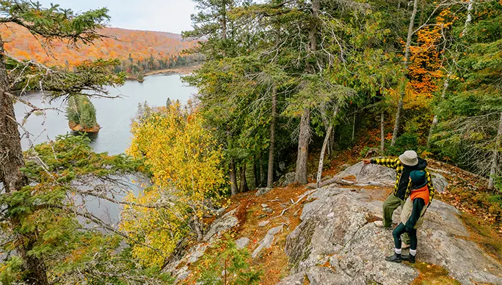
Top of the Sleeping Giant
When it comes to one of the best hikes in Ontario, Sleeping Giant Provincial Park wins hands down. The park has over 100 kilometres of trails, including the 22-kilometre trek to climb to the top of the Sleeping Giant. This challenging, full-day hike comes with an incredible reward: scenic views of Lake Superior from the top of Ontario’s tallest cliffs.
The park is located about an hour’s drive east of Thunder Bay. Pick up a day-use permit at the Marie Louise Lake campground and continue down Highway 587 to the South Kabeyun trailhead, at the small community of Silver Islet.
The trail begins easily along Lake Superior, with points of interest such as the Sea Lion rock arch and the sheltered waters of Tee Harbour and Lehtinen’s Bay. Next, it’s all uphill with several stunning lookout viewpoints, eventually arriving at a huge balcony of flat rock, the chest of the Sleeping Giant and one of Canada’s most recognizable landmarks.
Sleeping Giant Provincial Park features a drive-in campground and backcountry camping.
More to do near Sleeping Giant
The Silver Islet General Store is a must-stop in a quaint community that was once the site of the world’s most lucrative silver mine. Thunder Bay-based Sail Superior offers half- and full-day sailboat and Zodiac powerboat trips for a unique perspective of the Sleeping Giant.
Nipigon River Recreational Trail
The Lake Superior National Marine Conservation Area is the largest expanse of protected freshwater in the world. Get a sense of its immensity on this hike along what feels like an inland sea.
The one-way, 10-kilometre-long trail connects the communities of Nipigon and Red Rock, located approximately 90 minutes east of Thunder Bay on the Trans-Canada Highway.
Starting from Red Rock, the trail ascends through lush, mossy boreal forest where you can spot northern birds like Canada jays and spruce grouse. Ridgetop lookouts provide panoramic views of the islands and open waters of Nipigon Bay. Finally, the trail descends to the mouth of the Nipigon River, where back bays host handsome wood ducks, chattering kingfishers, busybody sandpipers and playful otters.
Check out local attractions
For nearby dining options, find hearty, home-cooked meals and friendly vibes in Nipigon. Stay in a historic log cabin on Lake Superior at The Lodge in Red Rock.
Red Rock comes alive each August for the Live from the Rock Folk Festival, featuring favourite Canadian artists.
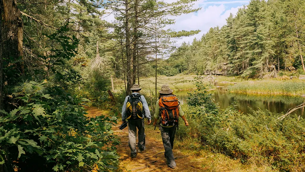
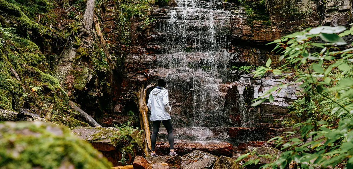
White River Suspension Bridge Trail
Pukaskwa National Park is known for the challenging, 60-kilometre-long backpacking Coastal Hiking Trail.
For a full-day adventure, hike the 18-kilometre out-and-back White River Suspension Bridge Trail, a portion of the coastal trail.
This well-marked hike includes a boardwalk along the wetlands of Hattie Cove and a perfect lunch spot at the sheltered, turquoise waters of Playter Harbour. The trail’s main attraction will make your knees quake: a swaying suspension bridge, soaring over 20 metres above a rushing cascade on the White River.
Pukaskwa’s Hattie Cove campground is noted for spacious and private sites for tents and trailers. Up the luxury by booking one of the park’s unique oTentik cabin tents.
More Pukaskwa hiking options
Pukaskwa is also home to some of Ontario’s best, less challenging hikes. Easy, family-friendly trails ascend headlands and visit pristine beaches near the park campground at Hattie Cove, about 15 minutes off the Trans-Canada Highway near Marathon.
For backcountry adventure, the White River Suspension Bridge is a short jaunt from Pukaskwa’s Mdaabi Miikna (“to the shore”) trail, a 24-kilometre loop with scenic Lake Superior campsites, perfect for an overnight or long-weekend backpacking trip.
Sault Ste. Marie and Algoma
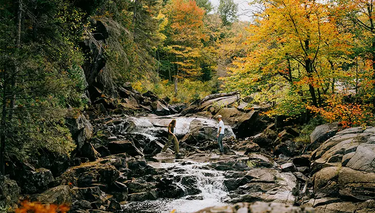
Orphan Lake Trail
With a dozen trails to choose from, it’s hard to identify the best hike in Lake Superior Provincial Park.
However, the eight-kilometre-long Orphan Lake Trail is among the best, featuring woods, waterfalls and beaches.
The Orphan Lake Trail is a great place to stop, stretch your legs and admire the spectacular scenery on the drive from Sault Ste. Marie to Wawa.
Start from the trailhead on Highway 17, about two hours north of Sault Ste. Marie. You’ll encounter lush hardwood forests of maple and yellow birch, a peaceful inland lake, tumbling waterfalls on the Baldhead River and surf-washed Lake Superior beaches. Set aside a half-day to complete this moderately difficult trail.
Pick up your day-use permit at the Lake Superior Provincial Park visitor centre at Agawa Bay. The facility features interpretive displays about the area and is located adjacent to one of the most scenic Ontario Parks campgrounds.
Nearby in Wawa
Rock Island Lodge offers waterfront accommodations, including glamping and camping options, on Lake Superior near Wawa.
Young’s General Store is a must-see attraction in Wawa.
Robertson Cliffs Trail
Located 30 minutes north of Sault Ste. Marie, the Robertson Cliffs Trail easily ranks among the best fall hikes in Ontario for its lofty views and hardwood forests of maple and oak trees bursting into red and orange.
This five-kilometre trail in the Algoma Highlands is stunning year-round. A strenuous ascent makes it a great fitness test, though Robertson Cliffs is also doable for families.
The trailhead is located off Highway 17. Head east onto Old Highway 17 Road, then turn right onto Robertson Lake Road and continue for approximately five minutes to reach two parking areas. The well-marked trail switchbacks uphill to vistas overlooking the Goulais River valley and Lake Superior, before looping back to the trailhead.
The trail, maintained by volunteers from the Algoma Highlands Conservancy, links to the Voyageur Trail for those who want to extend the hike.
Sault Ste. Marie is a trail town
Other great hiking trails in and around Sault Ste. Marie includes the Hiawatha Highlands, Gros Cap and the Sault Ste. Marie Canal National Historic Site.
Take a guided interpretive tour with Forest the Canoe or Indigenous-owned Walk Among the Trees.
Nearby accommodations include the Water Tower Inn and Bellevue Valley Lodge.
“The Soo” is home to several excellent Italian restaurants, so fuel your hike at Giovanni’s, Aurora’s or Gino’s Fired Up Kitchen.
Northeastern Ontario
Killarney Provincial Park
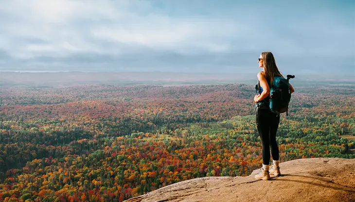
With the rugged quartzite landscape immortalized by the Group of Seven painters, hiking Northeastern Ontario’s Killarney Provincial Park can feel like you’re stepping into a classic piece of Canadian landscape art.
Bragworthy hiking trails include La Choche Silhouette Trail, a strenuous 80-kilometre loop that can take a week or longer to complete. Pick up a day-use permit from the George Lake Campground, about a 90-minute drive from Sudbury, and backtrack on Highway 637 about seven kilometres to a marked parking lot.
Explore Killarney and beyond
Besides the campground at George Lake, Killarney accommodations also include the upscale Killarney Mountain Lodge and off-grid Avalon Eco Resort.
No trip to Killarney is complete without a meal of local fish and chips at Herbert Fisheries, on the Georgian Bay waterfront.
Nearby Point Grondine Park and Campground is a quieter version of Killarney with almost 30 kilometres of wilderness hiking trails featuring incredible views.
Duchesnay Falls
In North Bay, add a great hike to your road trip itinerary.
The trailhead for this easy Ontario waterfall hike is on the Trans-Canada Highway, just west of downtown. The sound of rushing water erases highway noise almost immediately, as the trails climb alongside the east and west sides of a long series of cascades.
You could easily spend a half-day exploring nearly 12 kilometres of trails across the entire conservation area between the campuses of North Bay’s Nipissing University and Canadore College.
Also in North Bay
Twiggs Coffee Roasters is a North Bay favourite, with a cafe located on Cartier Street near the Duchesnay Falls trail.
North Bay embraces its Lake Nipissing waterfront with great swimming at Shabogesic Beach adjacent to downtown.
North Bay is also a hub for cycling, with fantastic urban riding on Kate Pace Way, countless road rides on the Voyageur Cycling Route and excellent mountain biking at the Three Towers trail network.
The Cup and Saucer Trail
Manitoulin Island is the largest island on the Great Lakes, with a mix of limestone geology and rolling pastoral hills that are reminiscent of the Bruce Peninsula—without the crowds.
The Cup and Saucer Trail showcases Manitoulin’s geological kinship to the Niagara Escarpment and is easily one of Ontario’s best hikes for its diversity of terrain.
Access to this eight-kilometre trail is located on Highway 540, near the community of M’Chigeeng. Two 440-million-year-old landforms resembling a stacked cup and saucer give the trail its name. You’ll ascend both to reach a penthouse view over the surrounding oak forests at the escarpment’s edge.
Take the half-day MS Chi-Cheemaun ferry from Tobermory to South Baymouth during the spring, summer and fall. You can also drive to Manitoulin via the Trans-Canada Highway, through the town of Espanola on Highway 6 and crossing the swing bridge at the town of Little Current.
Manitoulin Island traveller tips
Manitoulin Eco Park offers campsites, cabins and tipi rentals. This Dark Sky Preserve is one of the best spots for sky viewing and star watching in Ontario. Visit Wikwemikong First Nation for an authentic Indigenous experience, including guided cultural tours and accommodations. Manitoulin Brewing Company has a patio and food truck on the water in Little Current.
Lake Laurentian Conservation Area
For a community with the moniker “City of Lakes,” it makes sense that the best Sudbury hiking trails provide plenty of exposure to freshwater.
Minutes from downtown, the Lake Laurentian Conservation Area protects a large area of boreal forest, rock outcroppings, lakes and wetlands. It is also laced with over 35 kilometres of hiking and mountain biking trails.
The 10-kilometre-long Lake Laurentian Loop gives the best perspective on the area for those with the time and fitness level to tackle this challenging, half-day hike. There’s free parking at the P1 Access Point, just past Laurentian University on South Bay Road.
More Sudbury adventures
Science North is a top Sudbury attraction located on Ramsey Lake near the Lake Laurentian trail system.
In addition to hiking trails, Kivi Park in Sudbury offers rentals for canoeing and stand-up paddleboarding. The easy one-kilometre trek to spectacular waterfalls in the outlying community of Onaping Falls, said to inspire Group of Seven painter A.Y. Jackson.
Sudbury restaurants capture a variety of flavours, including the M.I.C (Made in Canada) Eatery for Canadian staples, the Apollo Restaurant, Sudbury’s original Greek restaurant and La Fromagerie for exceptionally cheesy lunches.
Hike to Recollet Falls in French River
The French River is part of an ancient navigational corridor between Georgian Bay and the Ottawa River.
An easy three-kilometre out-and-back trail starting from the French River Visitor Centre on Highway 69 is a great way to stretch your legs amidst the classic pines and polished granite landscape of Georgian Bay, while you trace this historic waterway.
More to do on the French River
The Lodge at Pine Cove offers luxe accommodations on the waterfront of this history river. Paddle into the past on a guided French River canoe trip with Black Feather Wilderness Adventures. Bear’s Den Lodge is an all-inclusive fishing and guiding resort with lodge and cabin-style accommodations.
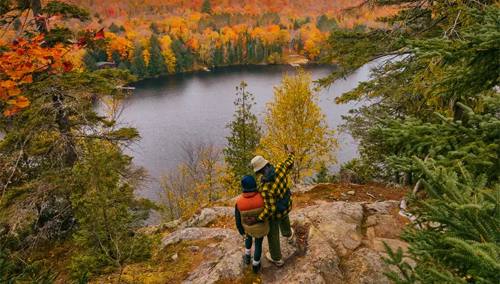
Algonquin Park, Muskoka and Parry Sound
Barron Canyon Trail
There are plenty of great day hikes in Algonquin Provincial Park — yet still it’s hard to believe the 1.5-kilometre Barron Canyon trail is often overlooked.
This easy hike, complete with a jaw-dropping 100-metre-high overlook, is located in the park's eastern corner, west of Highway 17 and Pembroke.
More to do in Algonquin Park
The nearest place to camp in Algonquin is the peaceful Achray Campground, located about five kilometres from the Barron Canyon trailhead.
The Barron River also makes a great canoe trip, with full-day and two- to three-day routes available. Algonquin Portage offers canoe rentals in Pembroke.
There are 15 Algonquin day hikes available along the park’s central Highway 60 corridor.
Bruce, Grey and Simcoe
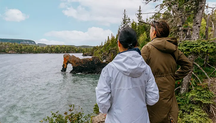
Lion’s Head Lookout
The Grotto in Bruce Peninsula National Park is a magnificent and extremely popular hiking destination along the legendary Bruce Trail.
Check out the Bruce Trail near Lion’s Head for similar Georgian Bay views and rugged limestone cliffs, with a fraction of the crowds. The challenging 18-kilometre Lion’s Head section offers some of the most spectacular scenery on the entire Bruce Trail.
Be sure to make a reservation well in advance to score a campsite at Bruce Peninsula National Park.
More about Bruce Peninsula
Cozy cabins, home-cooked food, fun events and great stargazing opportunities make Red Bay Lodge a wonderful stay nearby.
Fathom Five National Marine Park offers unique experiences that celebrate Georgian Bay, including island campsites, coastal hiking, boat tours and some of Canada’s finest scuba diving. Located on the tip of the Bruce, Tobermory is the gateway to Manitoulin Island via the MS Chi-Cheemaun Ferry.
Hamilton, Halton and Brant
Nassagaweya Canyon Trail
The eight-kilometre out-and-back Nassagaweya Canyon Trail in Milton is one of the best hikes near Toronto.
Lush, shady woods give way to lofty views from the crest of the Niagara Escarpment at Rattlesnake Point. Plan on at least a half-day to take it all in. Reservations are recommended.
More trails near Hamilton and Toronto
On a clear day, you can see the CN Tower from the Brock Harris Lookout in Mount Nemo Conservation Area, near Burlington.
Rouge National Urban Park in Scarborough offers 15 hiking trails to allow you to experience a range of natural habitats, including rare Carolinian forests, wetlands, grasslands and more.
The Don River is one of Toronto’s great urban waterways, linking the Oak Ridges Moraine to Lake Ontario. There are nine options available in the Walk the Don series of self-guided interpretive hikes.
The Bruce Trail offers hiking enthusiasts near Toronto hundreds of kilometres of scenic, accessible trails along the Niagara Escarpment, providing diverse landscapes, waterfalls, forests and cliffside views within easy reach of the city.
Southeastern Ontario
The Rideau Trail
The Rideau Trail is a remarkably long-distance hiking route that loosely follows the historic Rideau Canal, spanning roughly 450 kilometres linking two of the province’s most engaging cities, Ottawa and Kingston.
It traverses diverse landscapes ranging from rural, farm country and lakeside views to rugged Canadian Shield terrain, ecosystems and natural conservation areas.
Short day hikes, multi-day through-hikes, and everything in between make this trail appealing to hikers of all skill levels.
Maintained by the Rideau Trail Association, the group also organizes guided hikes, snowshoeing, cross-country skiing and educational activities.
Along the Rideau Trail
In terms of places to stay along the Rideau Trail, there are designated camping areas, as well as several hiker-friendly bed-and-breakfast accommodations nearby.
Ottawa Region
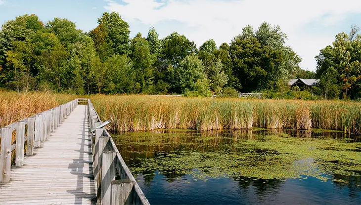
Mer Bleue Boardwalk Trail
Get a glimpse of Canada’s north in the nation’s capital at Ottawa’s Mer Bleue Bog.
Located only 20 minutes from downtown, this easy, kilometre-long boardwalk trail provides a close-up view of sphagnum moss, Labrador tea and the stunted spruce forest of one of Ontario’s southernmost peat bogs.
More outdoor experiences in Ottawa
Weekend Bikedays offer cyclists exclusive use of Ottawa parkways on weekends and holidays, May through early October.
The urban park at Kiweki Point on the Ottawa River offers interpretive panels and incredible views of Parliament Hill.
Become immersed in Canada’s Indigenous heritage during Summer Solstice at Mādahòkì Farm near Ottawa.
Whether you’re chasing waterfalls, scaling rugged cliffs or strolling through serene forests, Ontario's hiking trails promise unforgettable adventures.

Last updated: June 18, 2026