Find adventure on the Trans Canada Trail
Kenora | Destination Ontario
The Trans Canada Trail is the world’s longest recreational trail network.
In Ontario, the Trans Canada Trail connects over 150 communities across over 5,000 kilometres, from Minaki, north of Kenora on the Manitoba border in the west, to the Capital Pathway crossing from Ottawa into Quebec.
View the TCT map for the local trails that comprise the Trans Canada Trail in Ontario and locate the ones closest to you.
From cycling to hiking, here are five ways to experience adventure along this epic trail in Ontario.
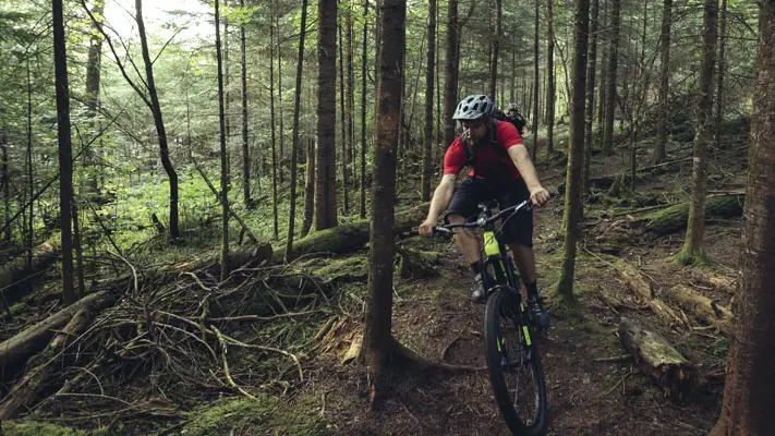
Explore by bicycle
Gear up your bike and strap on your helmet for breathtaking rides along the Trans Canada Trail. Keep in mind, some routes are multi-use, so watch out for pedestrians and hikers.
The Chrysler Canada Greenway
A scenic trail featuring rolling farmlands, vineyards, gardens, watersheds and welcoming communities, the Chrysler Canada Greenway is the southernmost section of the Trans Canada Trail.
Location and length: 51 kilometres between Kingsville and just south of Windsor, Essex County.
The Frontenac K&P Trail
Following a corridor of the former K&P Railway Company line, this trail cuts through the UNESCO-designated Frontenac Arch Biosphere, representing the ancient granite bridge linking the Canadian Shield in the north to the Adirondack Mountain range.
Location and length: 45.2 kilometres between Kingston and Sharbot Lake, Frontenac County.
Friendship Trail and Niagara River Recreational Trail
Pedal one of Canada’s most picturesque routes, from the town of Port Colborne on the north shore of Lake Erie, across Fort Erie and along the Niagara River to charming Niagara-on-the-Lake. Lush farm fields and vineyards, heritage downtowns, historic forts, waterfront parks and gardens and of course, the jaw-dropping Niagara Falls are all highlights along the way.
The level, paved and well-maintained trails are perfect for families and beginner cyclists.
Location and length: over 70 kilometres between Port Colborne and Niagara-on-the-Lake, Niagara Peninsula
The Lanark Link
This route presents cyclists the options of short touring loops, longer road trips and some trail riding, all with the scenic backdrop of gorgeous eastern Ontario Canadian Shield, farmlands and small hamlets and villages.
Location and length: over 100 kilometres between Smith Falls and Perth, Lanark County
Lake Huron North Channel
A portion of the Great Lakes Waterfront Trail offers cyclists unparalleled mixed urban and wilderness riding opportunities. Take in the views as you ride along forested roads, pass by picturesque farms and see the clear waters of Lake Huron.
Location and length: 374.78 kilometres between Sault Ste. Marie and Sudbury, Northern Ontario
Set out on a hike or walk
Whether it’s a short stroll or a multi-day hike, you can walk just about every land trail in Ontario.
Kabeyun Trail
The coastal trail starts at Thunder Bay Lookout, around the tip of the ‘Giant’ and ends at Kabeyun Trailhead on Highway 587. The hike is strenuous, but the mind-blowing view from the top of the Giant is the big payoff, worth every step of the way.
Location and length: 40 kilometres within Sleeping Giant Provincial Park, near Thunder Bay, Northwest Ontario
Waterfront Trail
Another arm of the extensive Great Lakes Waterfront Trail, this largely urban path hugs the shoreline of Lake Ontario.
It connects the waterfront communities of Burlington, Oakville, Mississauga and Toronto, featuring piers, gardens, beaches, local attractions and lovely lake views. Flat and paved, it’s wheelchair friendly and welcomes dogs on a leash.
Location and length: 90.22 kilometres between Burlington to Toronto, Greater Toronto Area
Voyageur Trail
This wilderness pedestrian-only trail showcases the rugged beauty of Algoma Country. Numerous access points allow for day trips to multi-day hikes. Classified as a wilderness trail, it is short on facilities, but not on spectacular scenery, from windswept beaches and wild forests to rocky ridges and showstopping lookouts.
Location and length: 188.49 kilometres between Sault Ste. Marie and Elliot Lake, Algoma
The Goderich to Guelph Trail Experience
The G2G Rail Trail is a scenic, multi-use route through diverse landscapes, including countryside and forest. Use the interactive map to identify connecting trails, as well as accommodations, food and supplies along the way.
Location and distance: Over 132 kilometres between Goderich and Guelph
Embark on a paddling trip
Ontario’s trails are not limited to land. Thousands of kilometres of freshwater lakes, rivers and navigable waterways provide some of the most rewarding paddling opportunities in the world.
The Lake Superior Water Trail
The shoreline of Lake Superior is a glorious, ancient aquatic highway offering spectacular natural sites and significant Indigenous cultural heritage.
This is bucket list kayaking and canoeing. There are 16 access points, including Gros Cap Marina Park near Sault Ste. Marie, which features a wheelchair accessible dock, making for an easier transition from chair to kayak.
Location and length: almost 1,000 kilometres linking Thunder Bay to Sault Ste. Marie, Northern Ontario
Path of the Paddle
Six connected water routes comprise this portion of the Trans Canada Trail, which meanders from the Manitoba border down to Kenora, snakes east through Vermilion Bay to Dryden, veers south to Atikokan and ultimately leads to the City of Thunder Bay.
These backcountry canoe and kayak trails cut through wilderness parks and lakes, offering epic adventure for experienced paddlers.
Location and length: 1,110 kilometres between the Manitoba border and Thunder Bay, Northwestern Ontario.
Plan a hybrid or mountain bike expedition
Diverse terrain and hair-raising routes make for some adrenaline-pumping off-road biking.
Old Nippising Road Connecter
Known as the Ontario Ghost Trail or the ‘forgotten trail’, this route was forged in 1850 to attract pioneers to new communities. Remnants of the failed settlements include abandoned cabins, cemeteries and ramshackle barns. Plus, its remaining dirt, tar and stone road serves as an awesome cycling and mountain biking trail today.
Location and length: 79.82 kilometres between Lake Rosseau and Lake Nipissing, Muskoka and Parry Sound District
Kawartha Trans Canada Trail
Long may you ride this four-season trail along a former railway route, through five communities, parklands, farmlands, wetlands and forests. Classic rock aficionados will want to cycle through Omemee, the childhood hometown of Canadian music legend Neil Young.
Cycling portions of the trail are suitable for hybrid and cyclocross bikes with a wider tire than traditional touring bikes.
Location and length: 53.8 kilometres between Uxbridge and Peterborough, Durham Region and the Kawartha Lakes.
The Cataraqui Trail
Following the former CN railway, the gravel surface and rough sections of this trail make hybrid or mountain bikes the best option for cycling. There’s also plenty of nature along the Cataraqui Trail, so you’re likely to see small animals and birds as you ride along the path.
Location and length: 81 kilometres between Harrowsmith and Smiths Falls, Eastern Ontario
Spot a variety of wildlife and birds
Calling all photographers, nature lovers and birders.
Cambridge to Paris Rail Trail
Running parallel to the Grand River, this trail was one of the first rail-to-trail projects converted in Ontario.
Visitors are treated to photo-worthy views of the river, a magical stretch through the Carolinian forest tunnel and fantastic bird watching opportunities. Birding hotspots nearby include the Dryden Tract and Bannister, Wrigley and Dickson conservation areas.
Location and length: 19.23 kilometres between Cambridge and Paris
Thornton Cookstown Trans Canada Trail, New Tecumseth Trail, Caledon Trailway and Elora Cataract Trailway
Four shared-use Trans Canada Trail systems stretch from just below Barrie south to the village of Elora and cut through farm pastures, forested woodlots, refreshing creeks and rolling hills and valleys. Look for deer, beavers, rabbits, raccoons, porcupines, foxes, groundhogs, turtles and various types of birds.
Location and length: over 100 kilometres between Thornton and Elora, Central Ontario
Tiny Trail
Wildlife and bird watching enthusiasts will have ample opportunities to capture the perfect shot as the trail intersects with the Wye River and Copeland Creek, and provides access to Tiny Marsh Wildlife Area, a significant wetland area.
Location and length: 18.93 kilometres between Midland and Elmvale
Check the status of each trail before you head out, as sections of the network are locally owned and operated. And familiarize yourself with the visitor guidelines for a responsible and safe experience.


Last updated: April 15, 2026